

Trucker Guide: The Smart Way to Navigate Low-Clearance Roads

To avoid bridge strikes in 2026, drivers should rely on commercial vehicle GPS like Trucker Guide that accounts for vehicle height and actively avoids low-clearance bridges. Since Waze and Google Maps are built for standard driving and don’t include true truck clearance routing, they can’t reliably prevent these kinds of incidents.
This is why even a small routing gap can quickly turn into costly damage, delays, and risks across drivers and fleets. So, let’s look at how missed low clearances can impact your truck route planning.
Key Facts:
- Low-clearance bridge strikes are a recurring safety issue in commercial trucking, often caused by routing or signage errors
- In 2024, New York State reported 350 bridge strikes involving commercial vehicles
- Low-clearance incidents can result in severe vehicle damage, cargo loss, and costly downtime
- Detours caused by routing errors increase fuel consumption and reduce available driving hours under HOS rules
- Truck-specific navigation systems help reduce risk by using vehicle height, weight, and route restrictions
What Are the Risks of Missing Low-Clearance Bridges for Truck Drivers?
Low-clearance bridges remain one of the most costly and preventable risks in trucking in 2026. It often starts with something small like a missed sign, a wrong turn, or overreliance on GPS, but once a truck is on the wrong route, the situation can escalate quickly.
When a commercial vehicle strikes a bridge, the outcome is usually immediate: the vehicle is taken out of service, cargo is compromised, and traffic disruption follows almost instantly. What makes these incidents especially serious is how many areas of operation are affected at the same time.
Beyond these outcomes, the key issue is how quickly a single mistake spreads across the entire operation. A bridge strike does not stay an isolated event. It interrupts schedules, increases costs, and creates pressure on both drivers and dispatch teams to recover lost time.
The real challenge in 2026 is that modern freight networks run tighter schedules and higher expectations, which means there is less room to absorb these disruptions once they happen.
How Do Trucking Apps Help Avoid Low-Clearance Roads and Bridges?
Technology has made a real difference in helping drivers avoid low-clearance accidents. Truck-specific navigation apps give drivers something regular GPS apps do not, which is awareness of truck restrictions built directly into the route.
With a commercial truck navigation app, drivers can enter key details like vehicle height, weight, and load type. The system then uses that information to guide them away from low bridges, restricted roads, and routes that are not safe for commercial vehicles. Real-time alerts also help by warning drivers about potential hazards ahead so they can adjust before it becomes a problem.
Another big advantage is the community side of it. Drivers regularly share updates about road conditions, closures, and clearance changes. That real-world input helps keep the data accurate and up to date in a way static maps cannot.
For fleets, apps with hazmat routing add another layer of safety by making sure sensitive cargo follows approved and compliant routes. In the end, it is not just about avoiding damage or fines. It is about keeping drivers safe and making smarter decisions on the road.
Which Truck Navigation Apps Avoid Low Bridges and No-Truck Roads?
Among the tools available today, Trucker Guide stands out as one of the most reliable navigation resources for low bridge avoidance. What makes it different is the combination of verified clearance data, live updates, and a user-friendly design.
Let’s take a closer look at how each feature helps drivers plan safer and more efficient routes:
1. Verified data: Trucker Guide uses reliable clearance information to ensure drivers know about bridge heights, weight limits, and other restrictions before they encounter them.
2. Fleet and driver confidence: Dispatchers and drivers can plan with one trusted system, reducing stress and preventing costly mistakes.
3. Built for trucking, not cars: Unlike general GPS apps, Trucker Guide is created specifically for commercial vehicles and integrates truck-focused safety features.
How Do You Use Trucker Guide for Low-Clearance Navigation?
Knowing about low-clearance risks is one thing. Using that knowledge on the road is another. Trucker Guide | Navigation makes it easy for drivers to take action, plan safe routes, and avoid surprises before they happen.
With a few simple steps, you can set up your route, see potential obstacles, and travel with confidence knowing your truck will fit safely through every bridge and overpass along the way.
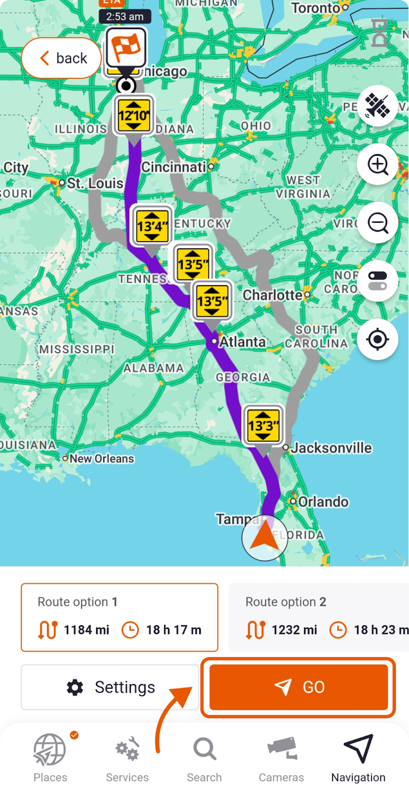
Step 1. Enter Your Destination
Begin by entering your destination in Trucker Guide | Navigation. The navigation app instantly creates the most efficient routes based on live traffic and road conditions.
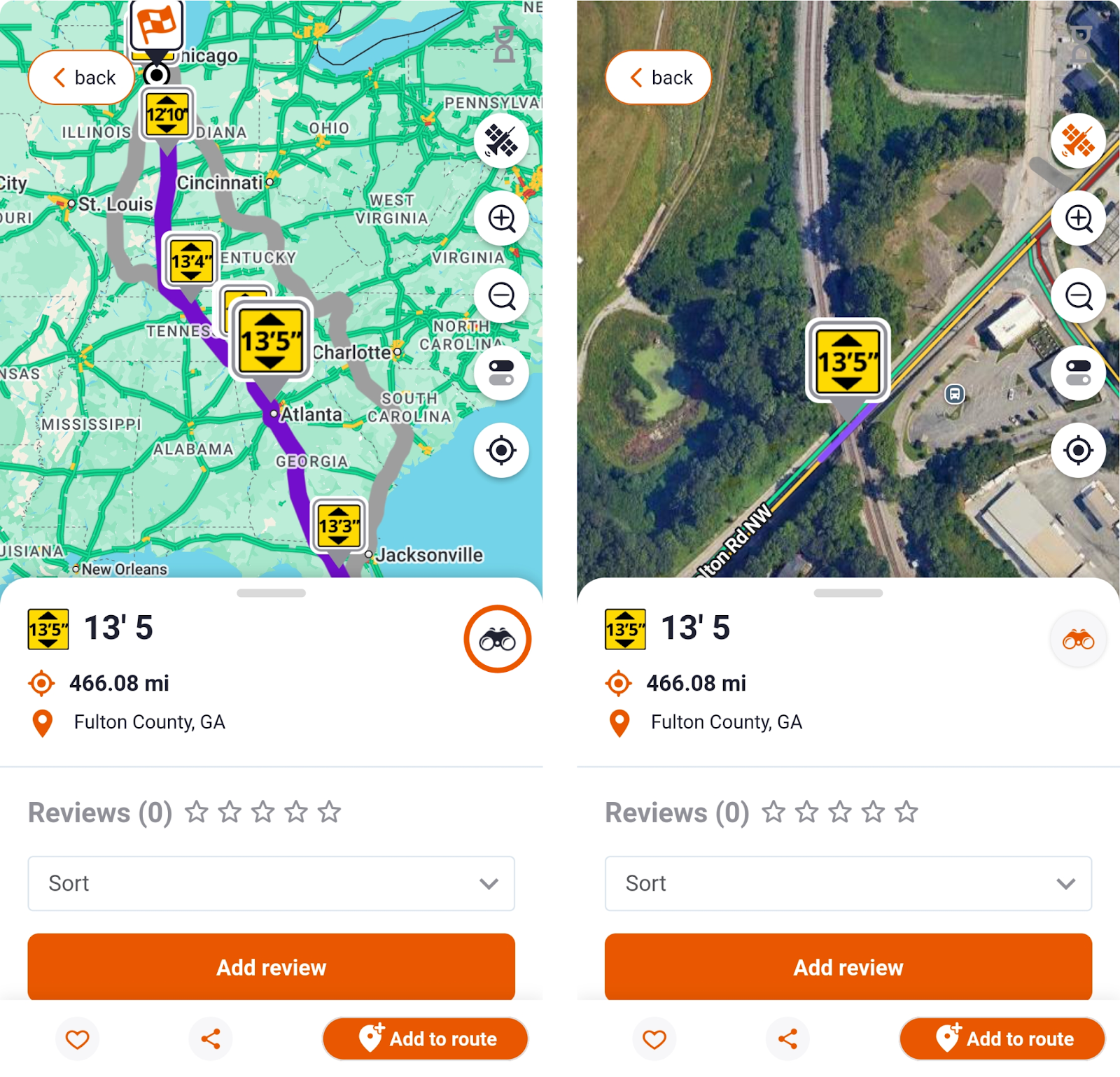
From the bottom menu, open the Places section and select the Low Clearances icon to display all low bridges along the route.
You May Also Like: Part 1. How to Build a Route with Trucker Guide | Navigation?
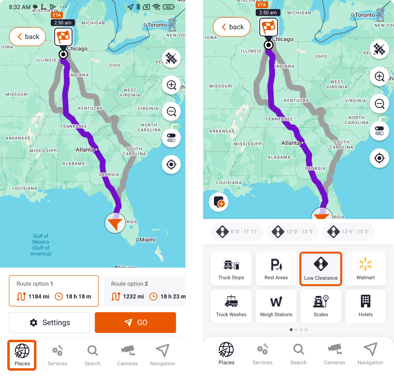
Tap any bridge height clearance icon for details or switch to satellite view for a closer look.
Step 2. Customize Truck-Specific Settings
Enter your truck’s exact height, weight, length, and axle count. This ensures the navigation system filters out roads and bridges that do not fit your truck. You can also avoid toll roads, ferries, tunnels, or sharp turns.
You May Also Like: Part 2. How to Get Truck-Specific Routing Customized to Your Truck?
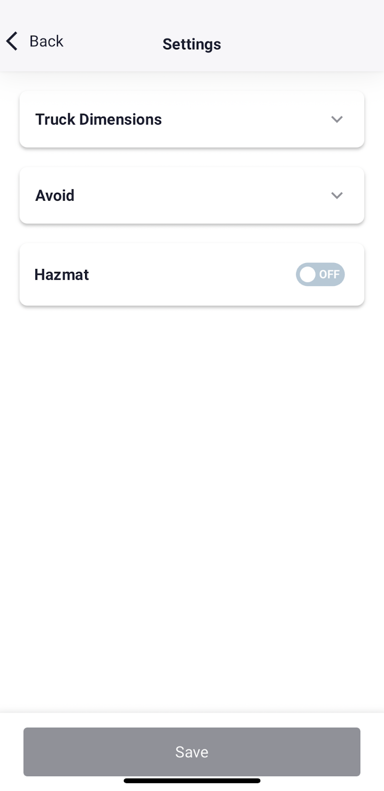
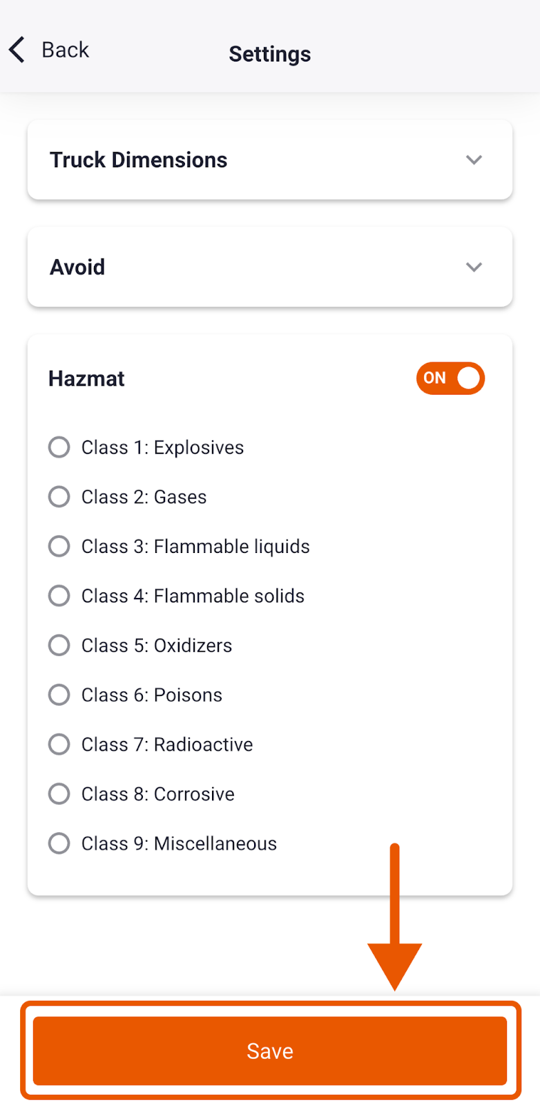
If you are transporting hazardous materials, compliance is essential. Trucker Guide | Navigation includes a dedicated hazmat routing mode, which automatically adjusts your route to meet federal and local safety regulations, helping you stay both safe and legal.
By saving your customized parameters, every turn, road restriction, and regulation is factored into the final route. Simply press the "Save" button to complete the setup and start your journey with confidence.
Step 3. Start Your Journey
Tap the “Go” button to activate navigation mode. Trucker Guide then provides turn-by-turn notifications, clearance alerts, and real-time updates, helping you stay safe, compliant, and on schedule.
You May Also Like: How Trucker Guide | Navigation Helps You Avoid Weigh Station Delays
Low-clearance accidents remain one of the most expensive and dangerous issues in trucking. Missed data on a map can cost fleets thousands of dollars, delay shipments, and even harm reputations. Trucker Guide eliminates that risk by giving drivers the information they need before they reach the roadblock.
With verified clearance data, real-time alerts, and truck-focused routing, it is more than an app. It is the best navigation partner for professional drivers who want to move freight safely and efficiently.
Try Trucker Guide | Navigation today to make every route safer, more efficient, and fully tailored to your truck’s specifications, giving you peace of mind on the road.
Frequently Asked Questions
What is the best GPS app to avoid low bridges?
The best GPS app for avoiding low bridges is Trucker Guide. It’s built specifically for professional CDL drivers and uses truck details like height, weight, and road restrictions to plan safe routes. This helps drivers automatically avoid low-clearance bridges and reduce the risk of expensive or dangerous routing errors.
Can Google Maps avoid low bridges for trucks?
No, Google Maps cannot reliably avoid low bridges for trucks because it is designed for passenger vehicles, not commercial truck routing. It does not account for truck height, weight limits, or legal road restrictions. Using it for CDL navigation can increase the risk of bridge strikes or restricted-road violations.
Is there a truck version of Waze?
Waze itself does not offer a dedicated truck navigation mode. However, some drivers use truck-specific apps that include community reporting features similar to Waze, but with added commercial routing tools. Dedicated trucking apps are still the safer option because they include bridge clearance and weight restriction data.
Where can I find a low-clearance bridge map for trucks?
You can find low-clearance bridge maps by using Trucker Guide, which integrates bridge height data directly into truck-specific routing. When you set your vehicle dimensions and plan a trip, it automatically highlights or avoids low-clearance bridges along the route. This helps drivers make safer decisions upfront and reduces the risk of bridge strikes on the road.
What is bridge height clearance and why does it matter for truckers?
Bridge height clearance is the maximum vertical space between the road and a bridge or overpass. It matters for truckers because exceeding that height can lead to severe collisions, vehicle damage, cargo loss, and safety hazards. Knowing clearance limits is essential for safe routing and compliance with trucking regulations.
Which truck navigation app handles bridge heights and weight limits best?
Truck navigation apps like Trucker Guide are designed specifically to handle bridge heights, weight limits, and other commercial restrictions. These systems allow drivers to input truck dimensions and automatically avoid unsafe routes. This reduces the risk of bridge strikes and ensures compliance with trucking regulations.


